


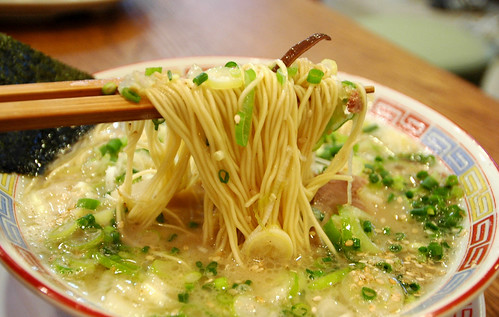
浦添市仲西 「風雲」の「ねぎラーメン」, originally uploaded by earthhopper.
CONTRIBUTED BY MEREDITH NOVARIO
Earthhopper takes some phenomenal shots of Okinawan soba and other foods found here on the island. Additionally, many of these pictures are geo-tagged which means something like if you click on the picture a map of the restaurant’s location will appear.
It’s pretty close to genius. I, however, am a long mile from genius. And even though earthhopper has VERY kindly tried to help me learn how to geo-tag places featured on the blog I remain baffled into a kind of paralysis.
ALSO, not totally sure we can do it in English. However, when I take a deep breath, I can read or decipher the maps despite not reading Japanese which means you can do it too.
You’ll notice to the right of these words are three pictures under the caption glimpses of okinawa. While many people contribute to THIS FLICKR GROUP, chances are good and high that if you see a steaming bowl of mouth-watering food then it’s earthhopper’s fine photo. And if it’s earthhopper’s work then it’s likely geo-tagged and that means you can go get it.
Am I making sense?
Give it a try.
Report back.
Sounds like you are puzzled too many Kanji charactors on Google Maps…
There are no online maps to provide Japan street map in English as far as I know, unfortunately.
One way is using satellite image mode of Google Maps (or Hybrid mode – change it by ) and seek location via actual buildings… but satellite mode has almost no landmark info on it, and hybrid is again, lots of Kanji.
Another option is using Google Earth. Have you ever use this amazing software? It has many optional layers of roads, landmarks and borders in English even for Japan, if you use it in English mode, I believe, so it should be much easier. After you find a location, put a marker on it, then copy the coordinates from it’s property, then bring it back to flickr geotagr or find very same place again on satellite image of Google Maps in geotagr.
Anyhow the principal cause is that flickr (Yahoo) don’t provide Japan street maps – if it does, everything will become very simple for you, but it’s unlikely to happen…
I think I’m just baffled by the technology. I want an English map. Is that possible? It all sort of makes my head spin. My husband is deploying next month so I’ll have more time to focus and try out your blow-by-blow geo=tagging instructions. But tell me, can we do it in English?
Thanks for writing this up 😉 – I am just nobody but a “Gachimaya” (a starving kid in Okinawan Language).
I put the write-up of a way of how-to-geotagging (click link on my name above), and did some rewrite and relink… let me know which step you are baffled and your questions…
flickr provides one-stop-shopping “flickr map”, but the reason why you’d better to do those steps is simply that they don’t provide street/house level map for Japan…
Also, these steps don’t make link for each map to jump to the map of the location instantly, unless you install Yuan’s GMiF extension to Firefox browser, or putting direct link of Google Map location into photo’s description. This way of geotagging is mainly for map-making.
Geotagging and map-making would be getting easier, and I guess adding coordinates data to each of your flickr photos wouldn’t be waste of your energy.
Anyhow, go get this Fuun ramen in Urasoe!