


Fukugawa Falls
CONTRIBUTED BY QUENTIN RICHARDSON
For those seeking adventure, Fukugawa falls is a great place to visit. Be prepared to hike, climb and swim all in one trip. You can also walk upstream to just to visit the falls to take pictures or even picnic along the route.
Fukugawa Trail
This site can serve as a great river trekking adventure if you are prepared. However, it is more dangerous and longer than the Taa Waterfall in Ogimi Village. First, bring a lot of bug spray and something to ward off the massive amount of spider webs. Next, footwear is important! Wear water-resistant shoes with a solid sole and good traction. Light, long sleeve shirts and pants help against mosquitoes. For safety reasons, do not travel this route alone. Finally, take your time and trek in the river (the second stretch) as much as you can unless you see flat ground. By the way, the water is COLD!
Fukugawa Group Trail

The Fukugawa Falls: The First Stretch
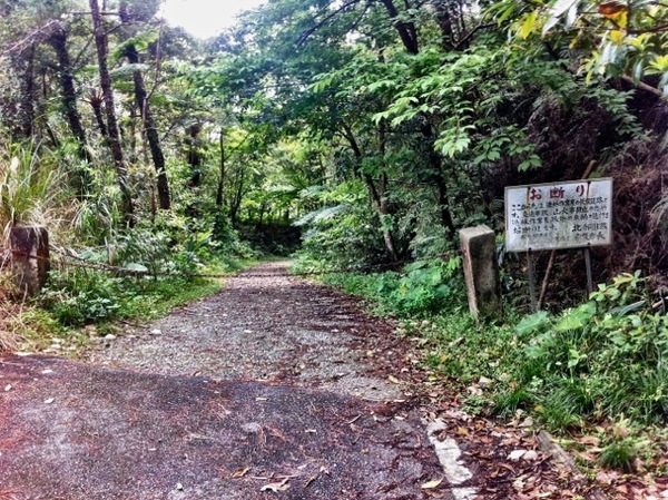
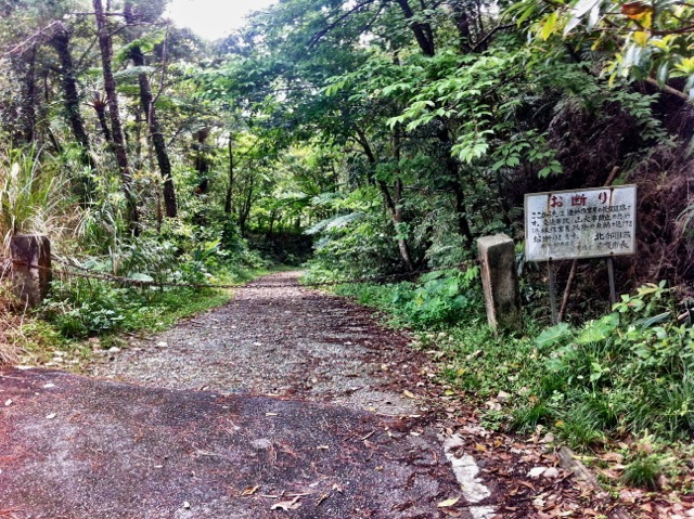
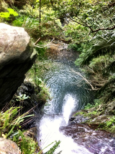
After passing the sign, there will be a long trail leading down to the first waterfall. Stay on the trail. You will walk downhill passing a flower farm, you cross over the stream via a bridge marking the halfway point. Continue down the path and you will reach the picnic area. The trail then turns into steps climbing a hill, at the hill’s summit you will be able to see the falls and its pool. Continue down the hill for Fukugawa Falls I. You can swim here and take pictures without worrying about crowds, since not too many people visit here.
The Fukugawa Falls: The Second Stretch
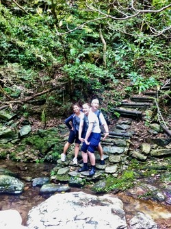
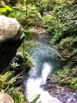
The start of this stretch begins at the top of the hill before the first set of falls. It will be a clearing on the left. WARNING! This trail is dangerous for young children (and adults who are not careful). It quickly climbs and wraps around the first waterfall and ends near to top of the fall. You can actually walk over to the edge of the waterfall and watch the water fall into the pool below (NEAT!).
The route upstream is now about 45 minutes to the next waterfall. Be prepared to get at least waist high deep in the stream in some areas and climbing up rocks in others, but stay in the stream as much as possible (usually easier). The rocks are very slippery, even when dry, so be careful. Once you reach the final destination, do not trek any farther. The waterfall here is very impressive and also has a pool to swim in.
Fukugawa Above Falls
Bring a waterproof camera, if not be careful since both falls seem to spray out. Also, a little backpack would be a smart thing to have since you will need both of your hands to balance yourself or support you along the trail. Since the area is deep in the mountains, cell phone reception doesn’t exist (at least for SoftBank users). Also check out Hiji Falls.
>Like our blog?
Grab a T shirt or souvenir from our shop. Or click through to Amazon using one of our links and do your usual shopping. It helps us keep the site going. Thanks for your support! Cheers
You will see stairs under a torii gate at the beginning of this left turn, drive past a few farms and end at a T-intersection where the trail begins.
Directions to Fukugawa Falls
This waterfall is beautiful! It is definitely worth the trip. However, we got very lost trying to find it and a local helped us find our way. My husband and I created some very detailed directions to help others who want to explore this part of Okinawa.
Google maps and Waze apps did not work-they took us up a very steep, narrow, windy road that our car would not make it through. Plus, we are not sure if it was the right way anyway- it seemed like we were driving into someone’s private property.
These are directions coming from south of the waterfall, from Nago.
Head north on 58
You will pass Phoenix Mansion (looks like a white apartment/hotel building) on your right. In 0.4 km you will see Kawakami intersection and turn right onto Kawakami.
Drive for 0.4 km. You will see a large radio tower antenna on your left. Turn left onto the bridge right after the radio tower.
Drive 2 km. You will see a white shed/old building on your right. Turn right onto the road immediately after this building.
At this point you are 3.1 km away from the entrance to the falls.
You will pass the dam on your left. Keep following this road. The water will be on your left.
At 1.7 km you will go over a bridge and reach a dead end. Turn right.
Continue to drive 1.4 km until you reach the parking area and entrance to the falls.
Great experience. We were lucky to ask some locals where the entrance was (there is a chain over the entrance). Just go down the path. Lots of overgrowth on the trails and lots of banana spiders. Come prepared. We also brought our dog and we made it to the second waterfall and he jumped in to go swim. He usually hates water but he overcame his fears once he saw me swimming.
So the directions kinda skip a part. They say turn at the radio, and then the road will end in an intersection. It took us about 30 min to find the falls this ways. Here is a revision with landmarks and mileage. So after you take that left at the radio antenna, go about 1 km and you will go into the tunnel. After the tunnel, about 2 km down is a gravestone monument, take that road to the left. THEN you will see the Torii gate to your left and you are on the right track. About 1-2 km down you will see the stone monument on your right, and that is about 3/4 the way. You soon come to the dead end (T-intersection) and the entrance is right there, and you can see the chain across the trail.
Do you know if pets are allowed? We like to take our dog on an many excursions as possible.
Both falls are amazing. The trek up to the second falls is definitely not for small children. LOTS of spider webs, so take Something to take them down to get through.
I just came back from the falls, it’s worth the trip just to see the first waterfall. These directions are great when coming from anywhere south of Nago. Just be sure to study the specified landmarks and you’ll be fine.
http://www.mapitokinawa.com/2012/01/fukugawa-falls.html
(1) If you are misled by the pin, yes, it is in the wrong spot.
(2) Here are updated directions:
Drive north on Hwy 58 and turn right at Kawakami intersection wihch is immediately after a small car dealership, there is a small grey statue on the right side after the light
Turn left on the bridge after the building with the radio antenna, follow this road under the tunnel, past Haneji Dam until you reach Makiya village.
From there…. use the road mapped out with this google link:
http://maps.google.com/maps?saddr=26.628607,128.038833&daddr=26.608050,+128.053795&hl=en&sll=26.628629,128.039458&sspn=0.001738,0.002401&geocode=Ff9RlgEdsbehBw%3BFbIBlgEdI_KhBw&dirflg=d&mra=ltm&t=m&z=15
You will see stairs under a torii gate at the beginning of this left turn, drive past a few farms and end at a T-intersection where the trail begins. Hope this helps
Yeah, my family tried this out on Mother’s Day and were not successful in locating the falls. Updated directions would be awesome!
does anyone have better directions (per previous commenter – these directions not good) ?????
These are probably the worst directions ever !
They lead to somewhere that is nowhere near where you need to go, it tells you to turn down the wrong street and then leads you to a run down path that is difficult to navigate. I suggest redoing them or taking them down, Because many more will try and use these directions and get lost like I did.